| Home | Rides | Reviews | Bikes | Gallery | Tech | Misc | Contact |
| The Mojave Road - 2010 Mo-Jazz does the Mo-Jav-ee by Martin Hackworth Photos: Martin Hackworth, Tony Forest. |
 |
|
|
|
|
| Each
year we make a winter pilgrimage from snowy Idaho south down I-15 to
ride the Mojave
Trail (a.k.a.
the Mojave Road) - an adventure that longtime MoJazz readers will know
has traditionally been way breezier than it ought to have been. After
several years of bone-numbing
cold this year we finally wised up and decided to delay our
trip
south until early spring. It was a good call. As is our usual custom, we used the AVI Casino, on the banks of the Colorado River in Laughlin, NV, as our base of operations. There is simply no better place to stay than the AVI for Mojave Road round trippers coming from the east since, in addition to great amenities, the trail literally begins at the edge of the parking lot. We were thrilled to encounter shorts, slaps and swimming pool weather as we walked out of the hotel and into the bright sunshine on the morning of March 27. What a difference three months makes. We'd anticipated great weather and spring conditions in the desert and were not disappointed. |
|
|
Our only issue this time was a tight time schedule
so we
were on the bikes and rolling out of the AVI lot before 8 a.m. Both
bikes, an XR650R and a WR450F, were equipped with Acerbis
Sahara
tanks. After 12+ gallons of premium unleaded between the two bikes from
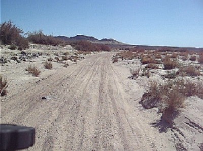
the gas station at the edge of the parking lot we were off. One simply could not have asked for finer weather: temperatures in the 60's with clear skies. Immensely cool! The only minor meteorological impediment was a stiff headwind out of the west that cropped up as soon as we crested the Dead Mountains 10 miles west of Laughlin. The Mojave Road is well marked with frequent rock cairns so GPS is largely superfluous for those planning on sticking exactly to the marked trail. We find it much easier to navigate between the rock cairns with dead reckoning anyway than trying to make sense of our tiny GPS screens at high speeds. The looking around method also has a rather obvious advantage of burning one's eyes with more scenery. A consequence of the warmer, drier spring weather was that the sand was much deeper and looser than we have encountered during our winter forays in the past. Fortunately my XR650R was shod with excellent Pirelli Scorpions which exert ferocious grip in loose sand. All that was necessary was to get things spinning up above 25 mph and the vast sandy stretches were nearly as casual as hardpack. |
|
We rolled rapidly through the Piute
Valley and
the 10 or so mile stretch across the Lanfair Plain was the
most
fun we've ever seen. Starting at the intersection of Old
Government
Road, Ivanpah-Lanfair Road and Cedar Canyon Road, 45 miles
from
Laughlin, the Mojave
Road meanders back and forth across the wide, flat and fast Cedar
Canyon Road as it heads west toward the New York Mountains. Rarely does
the Mojave Road, during this stretch, veer very far from Cedar Canyon
Road but it's still worth abandoning the dirt road
superhighway in
favor of the more interesting double track that wanders
leisurely
through the sagebrush and
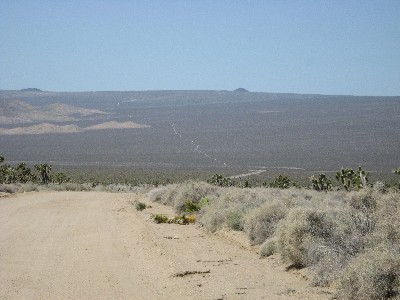
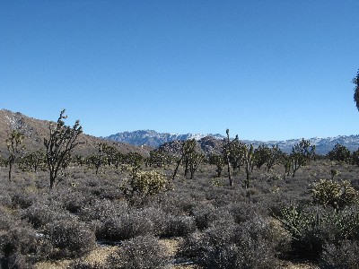
Joshua tree festooned plain. Upon cresting the pass through the New York Mountains one is greeted with an impressive vista. Ahead is a spectacular landscape that includes the Kelso Dunes to the south, the Beale and Marl Mountains in the center, and Cima Dome to the north. With out eyes glued to this tableau we descended a few miles along a rare stretch of pavement to Kelso-Cima Road and the Mojave Road Monument some 60 miles from Laughlin. |
|
 |
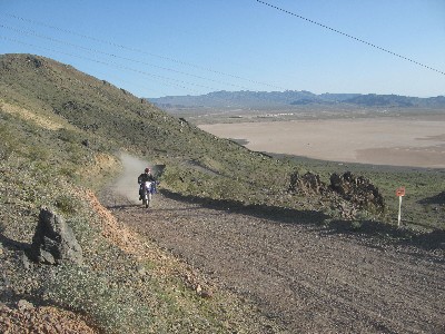
Next up were the whoops
- 12 miles of them up past Marl Springs to Powerline Road and beyond to
the Mojave
mailbox 74
miles from the AVI. No matter how many times we ride this stretch we
never tire of it - though we are almost always tired at the end of it. We
Hancocked the register at the mailbox and
after a brief rest proceeded down
Willow Wash. It is here that one encounters a frequent hazard lurking
beneath the
sand in this area of the Mojave Road: you should assume that
any
small rock that you see peeking up through
the sand, no matter how innocuous looking, is actually the tip of a
Titanic-sized boulder that is bolted directly to the center
of the earth. This will put you in the proper state of mind for what
happens if you square one up at speed.
|
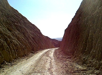
|
The Mojave Road Down
proceeds about 10
miles down
Willow Wash, past impressive basalt flows on the north, to KelBaker
Road. A
brief jaunt across the highway then it's a gentle descent westward
another 15 or so miles along Hidden Valley Road into Soda
Lake.
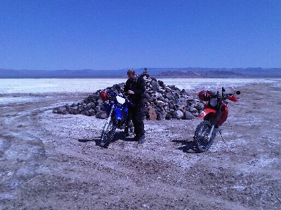
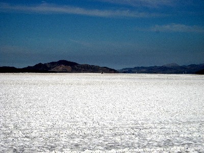
Soda Lake, at the terminus of the Mojave River, is a vast seasonal lake south of Baker, CA which is dry much of the time. During rainy season you have to detour north around the lake via Baker and Zzyzx Road (or Rasor Road if the water is really high). The Mojave Trail crosses the southern part of the lake and Traveler's Monument, a gathering spot for Mojave Road riders, is encountered near its west side about 100 miles from the Colorado River. |
|
|
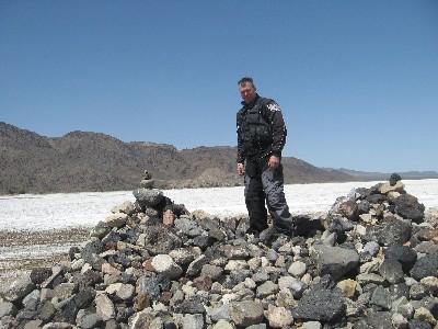
The
sandy wash west of
Traveler's
Monument leads to the Rasor OHV area 103 miles from the
Colorado
River. West
of the Rasor Dunes one rides several miles up the dry Mojave riverbed
to the head of a canyon where railroad tracks from the south
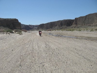
intersect the Mojave Road. Afton Canyon is an area with an interesting
mixture of natural and man made scenery with several water
crossings - a few of them quite deep.
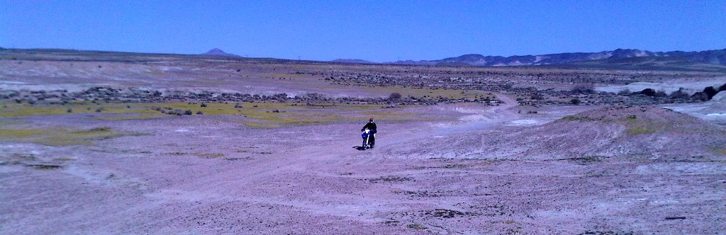
We followed the railroad tracks down Afton Canyon for about 10 miles to Afton Canyon Road and then steered west into the Manix Wash - a broad dry riverbed with very deep sand interspersed with stream boulders. Another 15 miles or so of sandy expanses and the Mojave Road climbs up a hill and ends at Yermo Road a few miles east of Yermo. The total Mojave Road distance from start to finish is around 125 miles. The closest gas is about 15 miles from this point and the closest major town, Barstow, is some 30 miles to the west. Warm temperatures and excellent riding conditions placed us at the end of the Mojave Road very early in the afternoon. With plenty of fuel and time left to burn we |
| detoured
north over the
Interstate toward Calico Hills OHV area where we spent some time before
taking frontage roads into Barstow.
The following morning we wanted to get back to the AVI as soon as possible to begin the 10 hour drive back to Idaho as soon as possible. We decided to take the 60 mile Powerline Road that parallels I-15 north of the interstate from Barstow to Baker as a much faster alternative to reversing the Mojave Road to Soda Lake. Powerline Road contains long sandy straights interspersed with the occasional windy road over a low mountain range and is both pleasant and fast. We rolled into Baker a little after 9 a.m. just in time for brunch at the Bun Boy. By 11 a.m. we were saddled up again and heading east around the northern edge of Soda Lake. We decided to detour north around Cima Dome and Teutonia Peak. Although none of this section of our ride is on the Mojave Road it's one of our favorite areas in the Mojave Preserve. Our route east climbed some 4800' in 30 miles to Teutonia Peak and the area around Cima Dome involved spectacular 360 degree panoramic views. |
 |
 |
A
steep descent
to the east dropped us onto Cima Road a few miles north of the Cima
Store where we stopped in for a howdy and a quick midday snack. From the Cima store we rode south 5 miles along Cima Road to Cedar Canyon Road and from there reversed our route along the Mojave Road back to the AVI. Having preridden this leg of the route just the day before we were able to put the hammer down and dispatch the last 60 miles in just under 80 minutes. Our total trip distance was 350 miles: 170 miles from Laughlin to Barstow via the Mojave Road and 180 miles back via the northern route. We encountered one large party on dirt bikes who managed to ride all of 60 miles in 24 hours due to the fact that they had to keep waiting for their Jeep wagon train to catch up. Our trail time on the Mojave Road was a leisurely six hours and less than that on the way back via a slightly longer route. Offhand we'd estimate that trailing support vehicles while riding dirt bikes is an exercise in futility. |
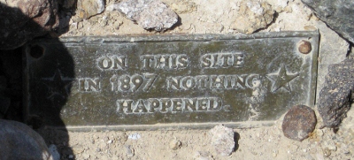
| Photos: Martin Hackworth and
Tony Forest 1. Manix Wash (near Yermo) 2. Kelso Dunes, Beale and Marl Mountains 3. Whoops near the Mojave Road Mailbox 4. Traveler's Monument, Soda Lake 5. Plaque at Traveler's Monument 6. Soda Lake 7. End of the Mojave Road near Yermo. 8. Afton Canyon 9. Soda Mountains (near Baker) 10. Joshua Trees near Cima Dome 11. Calico Hills 12. Traveler's Monument, Soda Lake |
 |
 |
Video:
Soda Lake (10.2 MB wmv) Mojave Whoops (260 MB wmv) Cima Dome (3 MB wmv) Cima Dome/Teutonia Peak (2 MB wmv) Check out our YouTube video page for more Mojave Road video Mojave Road Facebook Page Related Stories: The Mojave Trail A Night in the Desert The Mojave Loop The Mojave Road (desertusa.com) Reader Forum |
| Home | Rides | Reviews | Bikes | Gallery | Tech | Misc | Contact |